Shapes
Shapes
Higher-level geometry builders: the 2D shapes circle, ellipse, rectangle, ngon, annulus, arc, wedge, ribbon, con_rings, fishnet, hex_grid, and hex_field; the 3D solids cylinder, cone, dome, sphere, cube, pyramid, and soccer_ball; and fresnel_zone (a radio link's 3D Fresnel tube).
Sample files
2D shapes
These builders return flat KML geometry composed from the core
polygon, line, and
folder primitives. Unless a z_mode is passed, 2D
planar shapes clamp to the ground and follow the terrain, so a 2-element
[lon, lat] center works fine. Every builder forwards extra keyword arguments (z_mode,
style_to_use, hidden, headers, attrs, ...) to its underlying primitive.
Each also fills a default attribute table from its defining parameters (radius,
azimuth, center, and so on); pass explicit headers/attrs to override it.
circle
Approximates a circle of a given radius (meters) with a regular polygon of
steps vertices projected across the WGS-84 ellipsoid; more steps give a
smoother edge.
| Parameter | Type | Default | Description |
|---|---|---|---|
center |
list[float] |
required | [lon, lat] or [lon, lat, z] center. |
radius |
float |
required | Radius in meters. |
steps |
int |
48 |
Vertices around the circle; more gives a smoother edge. |
name |
str |
'Circle' |
Placemark name. |
**kwargs |
Any keyword argument accepted by polygon. |
Returns
Element: a KML Placemark containing the circle Polygon.
Raises
ValueError if steps is less than 3.
# A 37.5 m circle around the Parkman Bandstand on Boston Common.
kmlb.shapes.circle([-71.065510, 42.354345, 0], 37.5)
ellipse
Builds an ellipse from its two semi-axis lengths (meters) and an orientation. At
orient=0 the major axis runs north-south; increasing orient rotates it
clockwise from true north.
ellipse(center, semi_major, semi_minor, *, orient=0.0, steps=64,
        name="Ellipse", **kwargs) -> Element
| Parameter | Type | Default | Description |
|---|---|---|---|
center |
list[float] |
required | [lon, lat] or [lon, lat, z] center. |
semi_major |
float |
required | Half the long-axis length, in meters. |
semi_minor |
float |
required | Half the short-axis length, in meters. |
orient |
float |
0.0 |
Clockwise rotation of the major axis, degrees from true north. |
steps |
int |
64 |
Vertices around the ellipse. |
name |
str |
'Ellipse' |
Placemark name. |
**kwargs |
Any keyword argument accepted by polygon. |
Returns
Element: a KML Placemark containing the ellipse Polygon.
Raises
ValueError if steps is less than 3.
# A ~1200 m x 660 m ellipse off Point Shirley / Yirrell Beach, Winthrop, tilted 18 deg west of north.
kmlb.shapes.ellipse([-70.964514, 42.360287, 0], 600, 330, orient=-18)
rectangle
Builds a rectangle anchored at corner. azimuth is the compass bearing (degrees
from true north) of the rectangle's first (width) edge running from the corner:
the default 90 runs width due east and height due south, an upright box, so
corner is the upper-left corner. azimuth=0 points the first edge due north;
increasing azimuth turns the whole rectangle clockwise about the corner so it can
line up with a feature that is not north-up (which corner of the box corner
represents turns with it). height always runs 90 degrees clockwise of width.
| Parameter | Type | Default | Description |
|---|---|---|---|
corner |
list[float] |
required | [lon, lat] or [lon, lat, z] anchor (upper-left corner at the default azimuth=90). |
width |
float |
required | Length of the first edge (the one bearing azimuth), in meters. |
height |
float |
required | Length of the perpendicular edge (90 degrees clockwise of width), in meters. |
azimuth |
float |
90.0 |
Compass bearing of the first (width) edge, degrees from true north (0=north, 90=east). Default 90 runs width due east. |
name |
str |
'Rectangle' |
Placemark name. |
**kwargs |
Any keyword argument accepted by polygon. |
Returns
Element: a KML Placemark containing the rectangle Polygon.
# A ~1260 m x 185 m dock apron on the East Boston waterfront, anchored at its
# north-west corner. Default azimuth=90 runs the width edge due east.
kmlb.shapes.rectangle([-71.029345, 42.341506, 0], 1260, 185)

# The same apron rotated to line up with a quay that bears 110 degrees (its width
# edge now runs east-south-east instead of due east).
kmlb.shapes.rectangle([-71.029345, 42.341506, 0], 1260, 185, azimuth=110)
ngon
Builds a regular polygon of sides equal edges, each vertex radius meters from
the center. orient turns it clockwise; at orient=0 the first vertex points due
north.
| Parameter | Type | Default | Description |
|---|---|---|---|
center |
list[float] |
required | [lon, lat] or [lon, lat, z] center. |
radius |
float |
required | Distance from center to each vertex, in meters. |
sides |
int |
required | Number of sides (3 = triangle, 5 = pentagon, 6 = hexagon). |
orient |
float |
0.0 |
Clockwise rotation of the first vertex, degrees from true north. |
name |
str |
'Ngon' |
Placemark name. |
**kwargs |
Any keyword argument accepted by polygon. |
Returns
Element: a KML Placemark containing the regular-polygon Polygon.
Raises
ValueError if sides is less than 3.
# A pentagon over Fort Independence, the five-bastioned fort on Castle Island.
kmlb.shapes.ngon([-71.011100, 42.338233, 0], 100, 5)
annulus
Builds a filled ring: an outer circle with a smaller concentric inner circle punched out as a hole.
| Parameter | Type | Default | Description |
|---|---|---|---|
center |
list[float] |
required | [lon, lat] or [lon, lat, z] center. |
inner_radius |
float |
required | Inner (hole) radius, in meters; must be smaller than outer_radius. |
outer_radius |
float |
required | Outer edge radius, in meters. |
steps |
int |
48 |
Vertices around each circle. |
name |
str |
'Annulus' |
Placemark name. |
**kwargs |
Any keyword argument accepted by polygon. |
Returns
Element: a KML Placemark containing a Polygon with one hole.
Raises
ValueError if inner_radius is not smaller than outer_radius, or if steps is less than 3.
# A 100 m-wide band (inner 160 m, outer 260 m) around Snake Island, Winthrop.
# Radii are given inner first, then outer.
kmlb.shapes.annulus([-70.979528, 42.365842, 0], 160, 260)
arc
Draws a curved path at a fixed radius from a center point, sweeping from
start_az to end_az (degrees from true north). Returns a line, not a filled sector (use
wedge for a filled sector).
| Parameter | Type | Default | Description |
|---|---|---|---|
center |
list[float] |
required | [lon, lat] or [lon, lat, z] center. |
radius |
float |
required | Arc radius, in meters. |
start_az |
float |
required | Starting azimuth, degrees from true north. |
end_az |
float |
required | Ending azimuth, degrees from true north. |
steps |
int |
32 |
Segments along the arc. |
name |
str |
'Arc' |
Placemark name. |
**kwargs |
Any keyword argument accepted by line. |
Returns
Element: a KML Placemark containing the arc LineString.
# A field-of-fire arc for Fort Warren on Georges Island: a 550 m reach sweeping
# the harbor approach from north-east (46 deg) through south-east to south (172 deg).
kmlb.shapes.arc([-70.9285, 42.3199, 0], 550, 46, 172)
wedge
Builds a pie-wedge-shaped polygon: a circular sector centered on a point, opening
toward an azimuth, with a given angular width and radius. The arc is approximated
with steps vertices projected across the WGS-84 ellipsoid.
A wedge maps naturally onto a cellular coverage sector, which makes it a handy
way to illustrate cell-tower coverage. The azimuth is the direction the antenna
faces, the width is the sector's beamwidth, and the radius is its reach, so
the shape visualizes sector width, direction, and reach at a glance.
| Parameter | Type | Default | Description |
|---|---|---|---|
origin |
list[float] |
required | [lon, lat, elev] origin of the wedge (where its two straight edges meet). |
azimuth |
float |
required | Direction the center of the arc points, degrees from true north. |
width |
float |
required | Angular width of the wedge, in degrees. |
radius |
float |
required | Length of the wedge's straight edges, in meters. |
tilt |
float |
0.0 |
Elevation tilt of the whole sector, in degrees: 0 is flat on the ground, -90 points it straight down, 90 straight up. See the note below. |
steps |
int |
15 |
Number of vertices along the arc; more steps give a smoother curve. |
name |
str |
'Wedge' |
Placemark name. |
**kwargs |
Any keyword argument accepted by polygon (e.g. z_mode, style_to_use, hidden, headers, attrs). |
Returns
Element: a KML Placemark containing the wedge Polygon.
Raises
ValueError if steps is less than 2.
Tilt and altitude
A tilt lifts the sector off the ground, so it only renders under a
non-clamped altitude mode. When tilt is nonzero and no z_mode is given,
wedge selects 'ABS' (absolute) automatically and treats the center's z
as an absolute (MSL) altitude. Pass an explicit z_mode (for example
z_mode='RTG' to measure from the ground) to override.
Examples
A wedge opening due east
# A 30°-wide wedge of radius 1 km, opening due east from a center point.
w = kmlb.shapes.wedge([-71.0589, 42.3601, 0], azimuth=90, width=30, radius=1000)
An antenna sector with 6° of down-tilt
# The center z is an absolute altitude (antenna height above sea level); the
# sector tilts 6° below horizontal. z_mode defaults to 'ABS' when tilted.
w = kmlb.shapes.wedge([-71.0589, 42.3601, 45], azimuth=90, width=30, radius=1000, tilt=-6)
ribbon
Buffers an open path into a polygon by offsetting each vertex along the bisector
of its turn (a miter join), so the ribbon keeps an even width through bends.
Useful for trails, rail lines, pipelines, and flight corridors. Pass width as a
single value for an even width, or as a list (one value per path point) for a
ribbon that widens and narrows along its length, such as a hurricane track's wind
field.
| Parameter | Type | Default | Description |
|---|---|---|---|
path |
list[list[float]] |
required | Ordered [lon, lat] (or [lon, lat, z]) vertices, 2 or more. |
width |
float or list[float] |
required | Total width in meters: a single value, or one value per path point. |
name |
str |
'Ribbon' |
Placemark name. |
**kwargs |
Any keyword argument accepted by polygon. |
Returns
Element: a KML Placemark containing the ribbon Polygon.
Raises
ValueError if path has fewer than 2 points, or if a width list's length does not match path.
# A 45 m-wide ribbon down a path along the Rose Kennedy Greenway.
path = [
    [-71.051781, 42.358581], [-71.051176, 42.356909],
    [-71.051159, 42.356408], [-71.051254, 42.355748],
    [-71.051645, 42.355150], [-71.051895, 42.354950],
    [-71.053736, 42.353987],
]
kmlb.shapes.ribbon(path, 45)

# A variable-width ribbon: narrow at the ends, wide in the middle.
kmlb.shapes.ribbon(path, [20, 40, 60, 80, 60, 40, 20])
con_rings
Draws one unfilled circle outline per radius and returns them in a folder, so each
ring toggles on its own and carries a Ring/Radius attribute table. Give the radii
explicitly as radii, or generate an evenly spaced series with start,
interval, and count.
con_rings(center, radii=None, *, start=None, interval=None, count=None,
          steps=48, name="Concentric Rings", collapsed=True, hidden=False,
          **kwargs) -> Element
| Parameter | Type | Default | Description |
|---|---|---|---|
center |
list[float] |
required | [lon, lat] or [lon, lat, z] center all rings share. |
radii |
list[float] |
None |
Explicit radius for each ring, in meters. If None (the default), built from start/interval/count. |
start |
float |
None |
Innermost ring radius, in meters (generator form). |
interval |
float |
None |
Spacing between successive rings, in meters (generator form). |
count |
int |
None |
Number of rings to generate (generator form). |
steps |
int |
48 |
Vertices around each ring. |
name |
str |
'Concentric Rings' |
Folder name. |
collapsed |
bool |
True |
Whether the folder starts collapsed in the places panel. |
hidden |
bool |
False |
Whether the folder starts hidden. |
**kwargs |
Any keyword argument accepted by line; applied to every ring. |
Returns
Element: a KML Folder of line rings.
Raises
ValueError if neither radii nor all of start, interval, and count are given, or if steps is less than 3.
# Five range rings at 200 m intervals (200 m out to 1000 m) around Boston Light.
kmlb.shapes.con_rings([-70.890110, 42.327942, 0], start=200, interval=200, count=5)

# The same rings from an explicit list.
kmlb.shapes.con_rings([-70.890110, 42.327942, 0], [200, 400, 600, 800, 1000])
fishnet
Tiles a cols by rows grid of rectangular cells starting from an upper-left
corner and returns them in a folder; cells march along the top edge (column) and
90 degrees clockwise of it (row). Pass cell_dim as one value for square cells, or
[x, y] for rectangular cells (x along the columns, y along the rows).
azimuth is the compass bearing of the top (column) edge: the default 90 runs
columns due east and rows due south. Increasing azimuth turns the whole grid
clockwise about the corner. Every cell is clickable: pass ids to name the cells,
and each carries an ID/Row/Column attribute table.
fishnet(corner, cell_dim, cols, rows, *, azimuth=90.0, ids=None, labels=False,
        label_color=None, name="Fishnet", collapsed=True, hidden=False, **kwargs) -> Element
| Parameter | Type | Default | Description |
|---|---|---|---|
corner |
list[float] |
required | [lon, lat] or [lon, lat, z] anchor (upper-left corner at the default azimuth=90). |
cell_dim |
float or list[float] |
required | One value (square cells) or [x, y] (rectangular: x along the columns, y along the rows), in meters. |
cols |
int |
required | Number of columns. |
rows |
int |
required | Number of rows. |
azimuth |
float |
90.0 |
Compass bearing of the top (column) edge, degrees from true north (0=north, 90=east). Default 90 runs columns due east. |
ids |
list |
None |
Cell IDs, as a flat row-major list (rows * cols values) or a nested rows by cols list. Each names its cell and appears in its attribute table. When omitted, cells are named r{row}c{col}. |
labels |
bool |
False |
True puts the cells in a Cells subfolder and adds a sibling Labels subfolder with a text label at each cell's centroid (named by its ID), so each toggles on its own. |
label_color |
tuple |
None |
Color (hex, opacity) for the label dots. When None, they match the cells' outline color. |
name |
str |
'Fishnet' |
Folder name. |
collapsed |
bool |
True |
Whether the folder starts collapsed in the places panel. |
hidden |
bool |
False |
Whether the folder starts hidden. |
**kwargs |
Any keyword argument accepted by polygon; applied to every cell. |
Returns
Element: a KML Folder of polygon cells.
Raises
ValueError if cols or rows is less than 1.
Cell order for ids
Cells are built row by row from the corner, so a flat ids list is read in
that same order: the first row fills left to right along the top edge (columns
0, 1, ... cols-1), then the next row down, and so on. A flat list is therefore
[r0c0, r0c1, ..., r0c(cols-1), r1c0, ...] (index row*cols + col); a nested
list is indexed ids[row][col]. Every cell also carries Row and Column
values in its attribute table, so placement can be confirmed in Google Earth.
# A 20 m fishnet filling a rotated (diamond) parking lot in South Boston, anchored
# at the lot's north corner and rotated so the cells line up with the lot edge.
lot = [
    [-71.05038153, 42.34324057],   # west corner
    [-71.04865971, 42.34210311],   # south corner
    [-71.04721297, 42.34333098],   # east corner
    [-71.04895166, 42.34446722],   # north corner
]
cell = 20
cols = rows = max(1, round(kmlb.distance(lot[1], lot[2]) / cell))   # 9
# azimuth is the column-edge bearing, so aim it straight down the lot's top edge.
azimuth = kmlb.bearing(lot[3], lot[2])                              # north -> east corner
kmlb.shapes.fishnet(lot[3] + [0], cell, cols, rows, azimuth=azimuth)

# Rectangular 30 m x 20 m cells instead, with IDs for clickable, labelled cells.
# The flat list fills row by row: A1/A2/A3 across the top, then B1/B2/B3 below.
kmlb.shapes.fishnet(lot[3] + [0], [30, 20], 3, 2, azimuth=azimuth,
                    ids=["A1", "A2", "A3", "B1", "B2", "B3"])

# labels=True adds a "Labels" subfolder with each cell's ID shown on the map.
kmlb.shapes.fishnet(lot[3] + [0], cell, cols, rows, azimuth=azimuth, labels=True)
hex_grid
Tiles a cols by rows lattice of flat-top hexagons starting from an upper-left
corner, each of radius cell meters (center to vertex), interlocked edge to
edge. azimuth is the compass bearing of the column direction (default 90 runs
columns due east); increasing it turns the whole grid clockwise about the corner.
The rotation is rigid, so the hexagons stay tessellated at any azimuth. Cells are
clickable and ID-able just like fishnet.
hex_grid(corner, cell, cols, rows, *, azimuth=90.0, ids=None, labels=False,
         label_color=None, name="Hex Grid", collapsed=True, hidden=False, **kwargs) -> Element
| Parameter | Type | Default | Description |
|---|---|---|---|
corner |
list[float] |
required | [lon, lat] or [lon, lat, z] anchor (upper-left corner at the default azimuth=90). |
cell |
float |
required | Hexagon radius (center to vertex), in meters. |
cols |
int |
required | Number of columns. |
rows |
int |
required | Number of rows. |
azimuth |
float |
90.0 |
Compass bearing of the column direction, degrees from true north (0=north, 90=east). Default 90 runs columns due east. |
ids |
list |
None |
Cell IDs, flat row-major or nested rows by cols. When omitted, cells are named r{row}c{col}. |
labels |
bool |
False |
True puts the cells in a Cells subfolder and adds a sibling Labels subfolder with a text label at each cell's centroid (named by its ID), so each toggles on its own. |
label_color |
tuple |
None |
Color (hex, opacity) for the label dots. When None, they match the cells' outline color. |
name |
str |
'Hex Grid' |
Folder name. |
collapsed |
bool |
True |
Whether the folder starts collapsed in the places panel. |
hidden |
bool |
False |
Whether the folder starts hidden. |
**kwargs |
Any keyword argument accepted by polygon; applied to every cell. |
Returns
Element: a KML Folder of polygon cells.
Raises
ValueError if cols or rows is less than 1.
Cell order for ids
Cells are built row by row from the corner, so a flat ids list is read in
that same order: the first row fills left to right (columns 0, 1, ... cols-1),
then the next row down, and so on. A flat list is therefore
[r0c0, r0c1, ..., r0c(cols-1), r1c0, ...] (index row*cols + col); a nested
list is indexed ids[row][col]. Every cell also carries Row and Column
values in its attribute table, so placement can be confirmed in Google Earth.
# A hexagonal grid filling the same rotated South Boston parking lot as the fishnet
# example above, anchored at its north corner with columns bearing 131.38 degrees.
kmlb.shapes.hex_grid([-71.048952, 42.344467, 0], 12, 10, 9, azimuth=131.38)

# labels=True adds a "Labels" subfolder with each cell's ID shown on the map.
kmlb.shapes.hex_grid([-71.048952, 42.344467, 0], 12, 10, 9, azimuth=131.38, labels=True)
hex_field
Tiles a hexagon-shaped cluster of flat-top hexagons: a central cell surrounded by
rings rings of hexagons, so the whole cluster is itself a hexagon. Each hexagon
has a radius of cell meters (center to vertex) and the cells interlock edge to
edge. The total cell count is 1 + 3 * rings * (rings + 1) (7 at rings=1, 19 at
rings=2, 37 at rings=3). Cells are numbered 1, 2, 3, ... in a spiral outward
from the center, and each carries an ID/Ring attribute table.
hex_field(center, cell, rings, *, azimuth=90.0, ids=None, labels=False,
          label_color=None, name="Hex Field", collapsed=True, hidden=False, **kwargs) -> Element
| Parameter | Type | Default | Description |
|---|---|---|---|
center |
list[float] |
required | [lon, lat] or [lon, lat, z] center hexagon. |
cell |
float |
required | Hexagon radius (center to vertex), in meters. |
rings |
int |
required | Number of rings of hexagons around the center hexagon. |
azimuth |
float |
90.0 |
Clockwise rotation of the whole cluster about the center, degrees from true north. Default 90 is the base orientation; the rotation stays tessellated at any angle. |
ids |
list |
None |
Cell labels as a flat list of 1 + 3*rings*(rings+1) values in cell order (cell 1 the center, then ring by ring); ids[k] names cell k+1. When omitted, cells are named 1, 2, 3, ... |
labels |
bool |
False |
True puts the cells in a Cells subfolder and adds a sibling Labels subfolder with a text label at each cell's centroid (named by its ID), so each toggles on its own. |
label_color |
tuple |
None |
Color (hex, opacity) for the label dots. When None, they match the cells' outline color. |
name |
str |
'Hex Field' |
Folder name. |
collapsed |
bool |
True |
Whether the folder starts collapsed in the places panel. |
hidden |
bool |
False |
Whether the folder starts hidden. |
**kwargs |
Any keyword argument accepted by polygon; applied to every cell. |
Returns
Element: a KML Folder of polygon cells.
Raises
ValueError if rings is less than 1, or if ids is given with the wrong length.
Cell numbering
Cells are numbered in a spiral outward from the center: cell 1 is the center,
then the spiral winds through each ring (cells 2-7 are the first ring,
8-19 the second, and so on), so consecutive numbers are always neighbours. A
cell's Ring value (in its attribute table) is its ring number, 0 for the
center. Pass ids as a flat list in that same order to relabel the cells.
# Three rings of 60 m hexes; cells are auto-numbered 1..37 outward from the center.
kmlb.shapes.hex_field([-71.066, 42.355, 0], 60, 3)

# Label the 7 cells of a one-ring cluster (center first, then around the ring).
kmlb.shapes.hex_field([-71.066, 42.355, 0], 60, 1,
                      ids=["hub", "A", "B", "C", "D", "E", "F"])

# labels=True adds a "Labels" subfolder showing each cell's number on the map.
kmlb.shapes.hex_field([-71.066, 42.355, 0], 60, 3, labels=True)
Example: a 2D scene
Every 2D builder returns an ordinary KML element, so a scene is just a list of
them written with kml. This bundles a set of 2D builders into a single file,
each a plain one-line call spread across Boston Harbor.
import kmlb
from kmlb import shapes

# a path for the ribbon to follow (Rose Kennedy Greenway)
greenway = [
    [-71.051781, 42.358581], [-71.051254, 42.355748],
    [-71.051895, 42.354950], [-71.053736, 42.353987],
]

features = [
    shapes.circle([-71.065510, 42.354345, 0], 37.5),                        # Parkman Bandstand
    shapes.ellipse([-70.964514, 42.360287, 0], 600, 330, orient=-18),       # Point Shirley
    shapes.rectangle([-71.029345, 42.341506, 0], 1260, 185),                # East Boston dock
    shapes.ngon([-71.011100, 42.338233, 0], 100, 5),                        # Fort Independence
    shapes.annulus([-70.979528, 42.365842, 0], 160, 260),                   # Snake Island
    shapes.arc([-70.928500, 42.319900, 0], 550, 46, 172),                   # Fort Warren
    shapes.wedge([-71.067071, 42.354500, 0], azimuth=202.44, width=90, radius=60),  # ballfield, Boston Common
    shapes.ribbon(greenway, 45),                                            # Greenway path
    shapes.con_rings([-70.890110, 42.327942, 0], start=200, interval=200, count=5),  # Boston Light
    shapes.fishnet([-71.048952, 42.344467, 0], 20, 9, 9, azimuth=131.38),   # South Boston lot
    shapes.hex_field([-71.017548, 42.334915, 1], 40, 5, z_mode="RTG", labels=True),  # Pleasure Bay lagoon, 1 m up
]

kmlb.kml("2D shapes", features, path="shapes_2d.kml")
3D solids
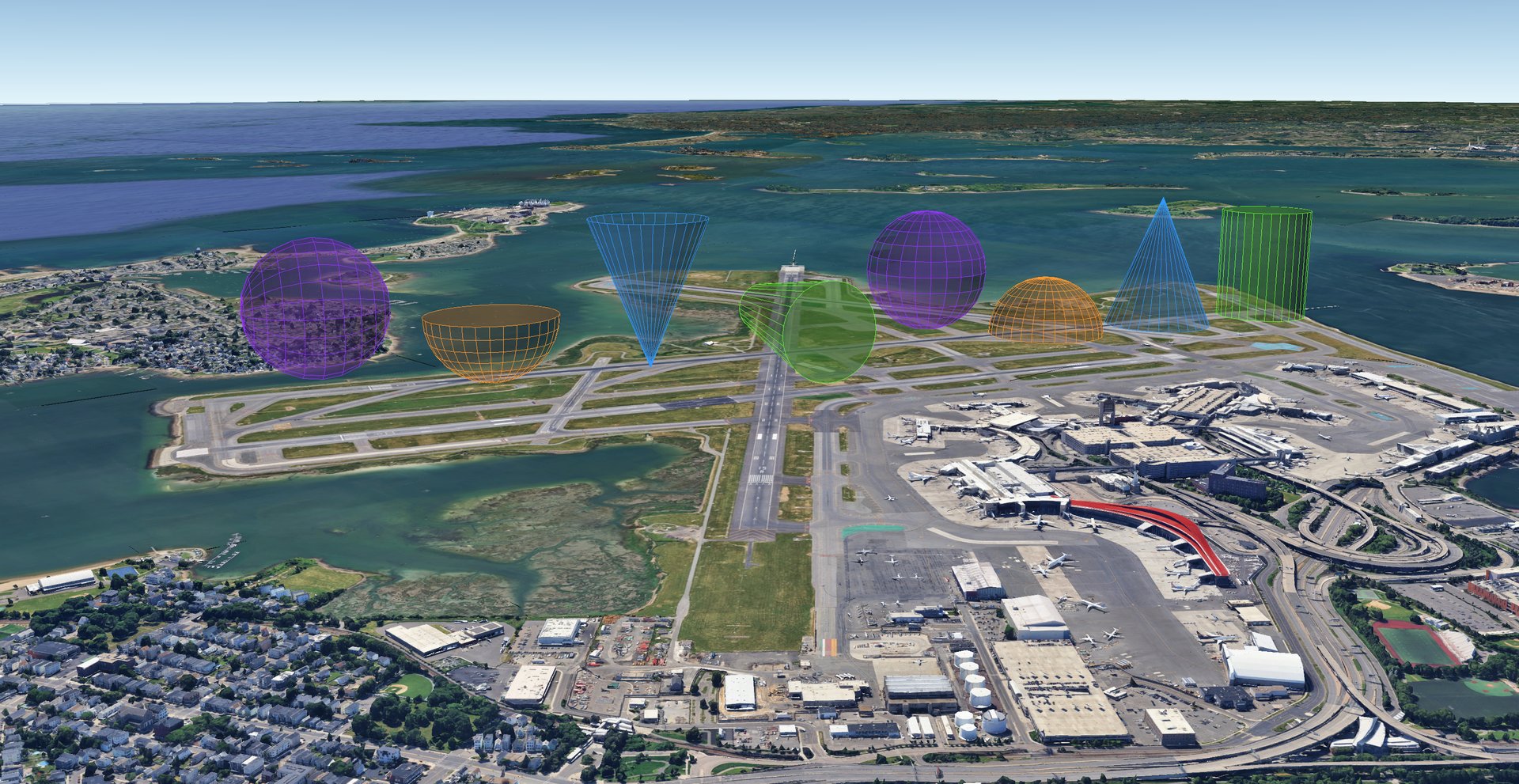
cylinder, cone, dome, sphere, cube, pyramid, and soccer_ball build
point-anchored 3D volumes at absolute altitude, so give coords a real (MSL)
z. Most return a single Placemark wrapping a <MultiGeometry> of polygon
panels (soccer_ball returns a folder of two).
Shared conventions
coords: the anchor point as[lon, lat, z].azimuth/tilt: aim the axis.tilt=90(default) stands the solid straight up,tilt=0lays it horizontal,tilt=-90points it down;azimuthis the compass bearing it leans toward when tilted.anchor: slides the body along the axis so its named point sits atcoords:'base'(near end, body extends along the axis),'center'(midpoint), or'top'(far end, body hangs back). All solids move the same direction, sosphere(mast, 5, anchor='base')rests the bottom pole on the mast tip, and a forward-openingconebeam isanchor='top'with the axis aimed byazimuth/tilt.headers/attrs: override the attribute table.style_to_use: name a shared polygon style to use instead ofcolor.cam: aLookAt/Cameradefault view.
Altitude and translucency
coords's z is an absolute MSL altitude, so give it enough height to clear
the terrain. The default fills are translucent (~40%), which Google Earth
renders with some see-through banding on a closed solid: a viewer limitation,
not a geometry issue. Raise the opacity for a more solid look.
cylinder
Builds a 3D cylinder volume: two radius end discs height apart along the
axis, joined by side panels.
cylinder(coords, radius, height, *, top_radius=None, azimuth=0, tilt=90,
         anchor="base", sides=32, color=("#66ff33", 40), cap=True, headers=None,
         attrs=None, style_to_use=None, name="Cylinder", z_mode="ABS", hidden=False,
         cam=None) -> Element
| Parameter | Type | Default | Description |
|---|---|---|---|
coords |
list[float] |
required | [lon, lat, z] anchor point; z is an absolute (MSL) altitude. |
radius |
float |
required | Base circle radius in meters. |
height |
float |
required | Length along the axis, in meters. |
top_radius |
float |
None |
Top circle radius in meters. None equals radius (a true cylinder); a different value tapers it into a frustum, and 0 closes it to a point like a cone. |
azimuth |
float |
0 |
Compass bearing the axis leans toward; only matters when the axis is tilted. |
tilt |
float |
90 |
Axis angle above horizontal: 90 = straight up, 0 = horizontal, -90 = straight down. |
anchor |
str |
'base' |
Which point sits at coords: 'base', 'center', or 'top'. See Shared conventions above. |
sides |
int |
32 |
Facets around the circumference; more gives a rounder solid. |
color |
color | ('#66ff33', 40) |
Fill color as a palette name, #rrggbb, or (color, opacity). The outline uses the same hue, opaque. |
cap |
bool |
True |
Close both ends with a disc. |
headers |
list |
None |
Titles for the attribute table (overrides the default). |
attrs |
list |
None |
Values for the attribute table, paired with headers. |
style_to_use |
str |
None |
Name of a shared polygon style to use instead of color. |
name |
str |
'Cylinder' |
Placemark name. |
z_mode |
str |
'ABS' |
Altitude mode; must be non-clamped for the solid to render. |
hidden |
bool |
False |
True returns the placemark hidden. |
cam |
Element |
None |
A LookAt/Camera default view. |
Returns
Element: a KML Placemark wrapping a MultiGeometry of the cylinder's panels.
Raises
ValueError if top_radius is negative.
# A 30 m safety cylinder over a helipad (10 m radius) at 52 m MSL.
kmlb.shapes.cylinder([-71.063187, 42.349164, 52], 10, 30)

# A tapered frustum (a cooling tower): 20 m base narrowing to an 11 m top.
kmlb.shapes.cylinder([-71.056307, 42.344475, 0], 20, 45, top_radius=11, z_mode="RTG")
cone
Builds a 3D cone volume: a radius base disc tapering to a point height away
along the axis. anchor slides the cone along the axis the same way it
moves the other solids: 'base' sits the base disc at coords with the apex out
along the axis, 'top' sits the apex at coords with the base hanging back.
cone(coords, radius, height, *, azimuth=0, tilt=90, anchor="base",
     sides=32, color=("#3399ff", 40), cap=True, headers=None, attrs=None,
     style_to_use=None, name="Cone", z_mode="ABS", hidden=False, cam=None) -> Element
| Parameter | Type | Default | Description |
|---|---|---|---|
coords |
list[float] |
required | [lon, lat, z] anchor point; z is an absolute (MSL) altitude. |
radius |
float |
required | Base radius in meters. |
height |
float |
required | Base-to-apex length along the axis, in meters. |
azimuth |
float |
0 |
Compass bearing the axis leans toward; only matters when the axis is tilted. |
tilt |
float |
90 |
Axis angle above horizontal: 90 = straight up, 0 = horizontal, -90 = straight down. |
anchor |
str |
'base' |
Which point sits at coords: 'base' (base disc), 'center', or 'top' (apex). See Shared conventions above. |
sides |
int |
32 |
Facets around the circumference; more gives a rounder solid. |
color |
color | ('#3399ff', 40) |
Fill color as a palette name, #rrggbb, or (color, opacity). The outline uses the same hue, opaque. |
cap |
bool |
True |
Close the base with a disc. |
headers |
list |
None |
Titles for the attribute table (overrides the default). |
attrs |
list |
None |
Values for the attribute table, paired with headers. |
style_to_use |
str |
None |
Name of a shared polygon style to use instead of color. |
name |
str |
'Cone' |
Placemark name. |
z_mode |
str |
'ABS' |
Altitude mode; must be non-clamped for the solid to render. |
hidden |
bool |
False |
True returns the placemark hidden. |
cam |
Element |
None |
A LookAt/Camera default view. |
Returns
Element: a KML Placemark wrapping a MultiGeometry of the cone's panels.
# A radio antenna mast: a slender apex-up cone, 45 m tall, atop a 171 m MSL tower.
kmlb.shapes.cone([-71.060854, 42.358412, 171], 3, 45)

# Its broadcast beam: apex at the mast top (216 m), tilted down and widening toward the ground.
# cap=False leaves the wide end open, so it reads as a beam rather than a solid cone.
kmlb.shapes.cone([-71.060854, 42.358412, 216], 30, 120, anchor="top", azimuth=90, tilt=10, cap=False)
dome
Builds a 3D hemisphere: a radius base disc rising in rings bands to a pole
one radius along the axis. Invert it (tilt=-90, anchor="top")
for a bowl.
dome(coords, radius, *, azimuth=0, tilt=90, anchor="base", sides=32,
     rings=8, color=("#ff9933", 40), cap=True, headers=None, attrs=None,
     style_to_use=None, name="Dome", z_mode="ABS", hidden=False, cam=None) -> Element
| Parameter | Type | Default | Description |
|---|---|---|---|
coords |
list[float] |
required | [lon, lat, z] anchor point; z is an absolute (MSL) altitude. |
radius |
float |
required | Radius in meters. |
azimuth |
float |
0 |
Compass bearing the axis leans toward; only matters when the axis is tilted. |
tilt |
float |
90 |
Axis angle above horizontal: 90 = straight up, 0 = horizontal, -90 = straight down (bowl). |
anchor |
str |
'base' |
Which point sits at coords: 'base', 'center', or 'top' (pole). See Shared conventions above. |
sides |
int |
32 |
Facets around the circumference; more gives a rounder solid. |
rings |
int |
8 |
Horizontal bands from rim to pole; more gives a smoother curve. |
color |
color | ('#ff9933', 40) |
Fill color as a palette name, #rrggbb, or (color, opacity). The outline uses the same hue, opaque. |
cap |
bool |
True |
Close the base with a disc. |
headers |
list |
None |
Titles for the attribute table (overrides the default). |
attrs |
list |
None |
Values for the attribute table, paired with headers. |
style_to_use |
str |
None |
Name of a shared polygon style to use instead of color. |
name |
str |
'Dome' |
Placemark name. |
z_mode |
str |
'ABS' |
Altitude mode; must be non-clamped for the solid to render. |
hidden |
bool |
False |
True returns the placemark hidden. |
cam |
Element |
None |
A LookAt/Camera default view. |
Returns
Element: a KML Placemark wrapping a MultiGeometry of the dome's panels.
# A 270 m no-fly-zone bubble over a Charles River fireworks show (base at river level).
kmlb.shapes.dome([-71.085106, 42.356654, 0], 270)
sphere
Builds a full 3D sphere centered on coords, extending radius in every
direction, meshed into sides facets around and rings bands pole to pole. It
is closed, so there is no cap.
sphere(coords, radius, *, azimuth=0, tilt=90, anchor="center", sides=24,
       rings=12, color=("#9933ff", 40), headers=None, attrs=None,
       style_to_use=None, name="Sphere", z_mode="ABS", hidden=False, cam=None) -> Element
| Parameter | Type | Default | Description |
|---|---|---|---|
coords |
list[float] |
required | [lon, lat, z] anchor point; z is an absolute (MSL) altitude. |
radius |
float |
required | Radius in meters. |
azimuth |
float |
0 |
Compass bearing the pole axis leans toward; only matters when the axis is tilted. |
tilt |
float |
90 |
Pole-axis angle above horizontal: 90 = upright, 0 = horizontal, -90 = inverted. |
anchor |
str |
'center' |
Which point sits at coords: 'center', 'base' (bottom pole), or 'top' (top pole). See Shared conventions above. |
sides |
int |
24 |
Facets around the equator; more gives a rounder sphere. |
rings |
int |
12 |
Bands from pole to pole; more gives a rounder sphere. |
color |
color | ('#9933ff', 40) |
Fill color as a palette name, #rrggbb, or (color, opacity). The outline uses the same hue, opaque. |
headers |
list |
None |
Titles for the attribute table (overrides the default). |
attrs |
list |
None |
Values for the attribute table, paired with headers. |
style_to_use |
str |
None |
Name of a shared polygon style to use instead of color. |
name |
str |
'Sphere' |
Placemark name. |
z_mode |
str |
'ABS' |
Altitude mode; must be non-clamped for the solid to render. |
hidden |
bool |
False |
True returns the placemark hidden. |
cam |
Element |
None |
A LookAt/Camera default view. |
Returns
Element: a KML Placemark wrapping a MultiGeometry of the sphere's panels.
# A 30 m sphere resting bottom-pole-down on a tower tip at 188 m MSL.
kmlb.shapes.sphere([-71.052183, 42.355688, 188], 30, anchor="base")
cube
Builds a cube, or a rectangular box, as six panels. Pass size as one
value for a cube, or [x, y, z] for a box: x across (east at azimuth 0), y
deep (north), z along the axis.
cube(coords, size, *, azimuth=0, tilt=90, anchor="base", color=("#ff5050", 40),
     cap=True, headers=None, attrs=None, style_to_use=None, name="Cube",
     z_mode="ABS", hidden=False, cam=None) -> Element
| Parameter | Type | Default | Description |
|---|---|---|---|
coords |
list[float] |
required | [lon, lat, z] base center; z is an absolute (MSL) altitude. |
size |
float or list[float] |
required | Edge length (cube) or [x, y, z] (box), in meters. |
azimuth |
float |
0 |
Compass bearing the axis leans toward; only matters when tilted. |
tilt |
float |
90 |
Axis angle above horizontal: 90 = straight up, 0 = horizontal, -90 = down. |
anchor |
str |
'base' |
Which face sits at coords: 'base', 'center', or 'top'. |
color |
color | ('#ff5050', 40) |
Fill color; the outline uses the same hue, opaque. |
cap |
bool |
True |
Close the two end faces. |
headers |
list |
None |
Titles for the attribute table (overrides the default). |
attrs |
list |
None |
Values for the attribute table, paired with headers. |
style_to_use |
str |
None |
Name of a shared polygon style to use instead of color. |
name |
str |
'Cube' |
Placemark name. |
z_mode |
str |
'ABS' |
Altitude mode; must be non-clamped for the solid to render. |
hidden |
bool |
False |
True returns the placemark hidden. |
cam |
Element |
None |
A LookAt/Camera default view. |
Returns
Element: a KML Placemark wrapping a MultiGeometry of the box's panels.
# A 170 m cube enclosing a park, resting on the ground (z_mode="RTG"). The park's
# two opposite corners are ~166 m apart, so a single 170 m size covers the footprint.
kmlb.shapes.cube([-71.032344, 42.336542, 0], 170, anchor="base", z_mode="RTG")

# A 60 x 30 x 120 m tower block instead: pass [x, y, z] (x along azimuth, y across, z up).
# azimuth=302 runs the long 60 m side along ~32 deg to fit the parcel.
kmlb.shapes.cube([-71.058717, 42.347704, 0], [60, 30, 120], anchor="base", azimuth=302, z_mode="RTG")
pyramid
Builds a 3D pyramid: a regular polygon base of sides edges rising to a single
apex. The default sides=4 gives a square pyramid, and more sides
approach a cone. orient spins the base about the axis so a corner or a flat side
faces a chosen direction.
pyramid(coords, radius, height, sides=4, *, orient=0.0, azimuth=0, tilt=90,
        anchor="base", color=("#ffcc00", 40), cap=True, headers=None, attrs=None,
        style_to_use=None, name="Pyramid", z_mode="ABS", hidden=False, cam=None) -> Element
| Parameter | Type | Default | Description |
|---|---|---|---|
coords |
list[float] |
required | [lon, lat, z] base center; z is an absolute (MSL) altitude. |
radius |
float |
required | Base center-to-corner distance, in meters. |
height |
float |
required | Base-to-apex length along the axis, in meters. |
sides |
int |
4 |
Number of base sides (3 or more). |
orient |
float |
0.0 |
Rotation of the base about the axis, in degrees. |
azimuth |
float |
0 |
Compass bearing the axis leans toward; only matters when tilted. |
tilt |
float |
90 |
Axis angle above horizontal: 90 = straight up, 0 = horizontal, -90 = down. |
anchor |
str |
'base' |
Which point sits at coords: 'base', 'center', or 'top' (apex). |
color |
color | None |
Fill color; the outline uses the same hue, opaque. When omitted, chosen by base edge count from shapes.PYRAMID_PALETTE (triangle, square, pentagon, ... each differ). |
cap |
bool |
True |
Close the base with a polygon. |
headers |
list |
None |
Titles for the attribute table (overrides the default). |
attrs |
list |
None |
Values for the attribute table, paired with headers. |
style_to_use |
str |
None |
Name of a shared polygon style to use instead of color. |
name |
str |
'Pyramid' |
Placemark name. |
z_mode |
str |
'ABS' |
Altitude mode; must be non-clamped for the solid to render. |
hidden |
bool |
False |
True returns the placemark hidden. |
cam |
Element |
None |
A LookAt/Camera default view. |
Returns
Element: a KML Placemark wrapping a MultiGeometry of the pyramid's panels.
Raises
ValueError if sides is less than 3.
# Three pyramids following the Rose Kennedy Greenway, each with a 40 m-wide base
# oriented along the path (orient=125, its bearing) and resting on the ground
# (z_mode="RTG"). With no color given, each base-count takes a PYRAMID_PALETTE color.
kmlb.shapes.pyramid([-71.056663, 42.362658, 0], 20, 90, orient=125, z_mode="RTG")            # square (4-side)
kmlb.shapes.pyramid([-71.055614, 42.362052, 0], 20, 120, sides=3, orient=125, z_mode="RTG")  # triangular
kmlb.shapes.pyramid([-71.054195, 42.361390, 0], 20, 90, sides=6, orient=125, z_mode="RTG")   # hexagonal
soccer_ball
Builds a soccer ball: a truncated icosahedron of 12 pentagon and 20 hexagon faces, two-tone (dark pentagons, light hexagons by default). Returned as a folder of two placemarks so each color toggles on its own.
soccer_ball(coords, radius, *, azimuth=0, tilt=90, anchor="center",
            colors=(("#111111", 100), ("#ffffff", 100)), headers=None, attrs=None,
            style_to_use=None, name="Soccer Ball", z_mode="ABS", hidden=False,
            collapsed=True, cam=None) -> Element
| Parameter | Type | Default | Description |
|---|---|---|---|
coords |
list[float] |
required | [lon, lat, z] ball center; z is an absolute (MSL) altitude. |
radius |
float |
required | Radius in meters. |
azimuth |
float |
0 |
Compass bearing the pole axis leans toward. |
tilt |
float |
90 |
Pole-axis angle above horizontal. |
anchor |
str |
'center' |
Which point sits at coords: 'center', 'base', or 'top'. |
colors |
color or pair | (('#111111', 100), ('#ffffff', 100)) |
A single color for both face types, or a (pentagon_color, hexagon_color) pair. |
headers |
list |
None |
Titles for each placemark's attribute table. |
attrs |
list |
None |
Values paired with headers. |
style_to_use |
str |
None |
Name of a shared polygon style to use on both placemarks instead of colors. |
name |
str |
'Soccer Ball' |
Folder name. |
z_mode |
str |
'ABS' |
Altitude mode; must be non-clamped for the solid to render. |
hidden |
bool |
False |
True returns the folder hidden. |
collapsed |
bool |
True |
Whether the folder starts collapsed. |
cam |
Element |
None |
A LookAt/Camera default view for the folder. |
Returns
Element: a KML Folder holding the pentagon and hexagon placemarks.
# A small two-tone soccer ball resting on Boston Common.
kmlb.shapes.soccer_ball([-71.067507, 42.355289, 0], 8, anchor="base", z_mode="RTG")
Example: solids along a path
Each solid is an ordinary KML element, so a scene is just a list of them. This places one of each equally spaced along a path, then repeats with oriented variants (a tapered cylinder (frustum) on its side, an inverted open-ended cone, a bowl, and a sphere with its pole axis along the path).
The 3D solids and their oriented variants, viewed in Google Earth.
import kmlb

# Path for shapes to follow
a, b = [-71.014092, 42.353934], [-71.003726, 42.375887]   # [lon, lat]
d = kmlb.distance(a, b)
az = kmlb.bearing(a, b)

# eight equally spaced points along the path, at 60 m altitude
pts = [kmlb.destination(a, az, i / 7 * d)[:2] + [60.0] for i in range(8)]

solids = [
    kmlb.shapes.cylinder(pts[0], 120, 300),
    kmlb.shapes.cone(pts[1], 140, 350),
    kmlb.shapes.dome(pts[2], 150),
    kmlb.shapes.sphere([pts[3][0], pts[3][1], 250], 150),
    # oriented variants
    kmlb.shapes.cylinder([pts[4][0], pts[4][1], 150], 120, 400, top_radius=60, azimuth=az + 90, tilt=0, anchor="center"),
    kmlb.shapes.cone(pts[5], 140, 350, tilt=-90, anchor="top", cap=False),   # inverted, open (no base cap)
    kmlb.shapes.dome(pts[6], 150, tilt=-90, anchor="top"),          # bowl
    kmlb.shapes.sphere([pts[7][0], pts[7][1], 250], 150, azimuth=az, tilt=0),
]

kmlb.kml("3D solids", solids, path="shapes_3d.kml")
fresnel_zone
Builds the Fresnel zone of a point-to-point radio link as a 3D ellipsoid tube
(a MultiGeometry of polygon panels) around the line of sight, and, by default,
the straight line-of-sight path as well. The two are returned together in a
folder so each can be toggled on its own in Google Earth.
The tube is inherently three-dimensional, so it uses absolute altitude: each
endpoint's z should be an absolute (MSL) antenna altitude.
fresnel_zone(point_a, point_b, freq_mhz, *, name="RF Link", zone=1,
             cross_rings=25, ring_strips=16, zone_color=("yellow", 40),
             include_path=True, path_color="red", center_ring_color="cyan",
             z_mode="ABS", collapsed=True, hidden=False, cam=None) -> Element
| Parameter | Type | Default | Description |
|---|---|---|---|
point_a |
list[float] |
required | First endpoint [lon, lat, z]; z is an absolute (MSL) altitude. |
point_b |
list[float] |
required | Second endpoint [lon, lat, z]; z is an absolute (MSL) altitude. |
freq_mhz |
float |
required | Link frequency in megahertz. |
name |
str |
'RF Link' |
Link name. |
zone |
int |
1 |
Fresnel zone number to draw. |
cross_rings |
int |
25 |
Cross-section rings along the link; more gives a smoother tube lengthwise. |
ring_strips |
int |
16 |
Strips (facets) around each cross-section; more gives a rounder tube. |
zone_color |
color | ('yellow', 40) |
Tube color as a palette name, #rrggbb hex, or (color, opacity) pair. The outline uses the same hue at full opacity. |
include_path |
bool |
True |
True also draws the line-of-sight path; False omits it. |
path_color |
color | 'red' |
Line-of-sight path color, in the same forms as zone_color. |
center_ring_color |
color | 'cyan' |
Color of a hoop drawn at the widest (mid-path) cross-section, in the same forms as zone_color. Set to None to omit it. |
z_mode |
str |
'ABS' |
Altitude mode. The tube only renders under a non-clamped mode. See Altitude modes. |
collapsed |
bool |
True |
False returns the folder expanded; True (default) returns it collapsed in the places panel. |
hidden |
bool |
False |
True returns the folder hidden. |
cam |
Element |
None |
A LookAt/Camera default view for the returned folder (or the bare tube). |
Returns
Element: a KML Folder holding the tube plus the line-of-sight path and/or
the center ring whenever either is drawn, or the tube Placemark on its own
when both include_path is False and center_ring_color is None.
Raises
ValueError if point_a and point_b are the same location, if cross_rings is less than 2, or if ring_strips is less than 3.
Absolute altitude
Endpoint z values must be real (MSL) antenna altitudes. The tube is drawn
at absolute altitude so it sits in space between the towers; a z of 0
would anchor the link at sea level.
Example
A 5.8 GHz link between two towers
# Endpoint z values are absolute antenna altitudes (meters above sea level).
link = kmlb.shapes.fresnel_zone([-71.082399, 42.347435, 228],
                                [-71.058514, 42.358468, 182],
                                freq_mhz=5800, name="North Link")
kmlb.kml("Link Study", [link], path="link.kml")
Example: a combined RF scene
Shapes are ordinary KML elements. Several can be added to document. This sample
builds a down-tilted antenna sector and a point-to-point Fresnel Zone on two
corners of the same building, then writes them to a single .kml.
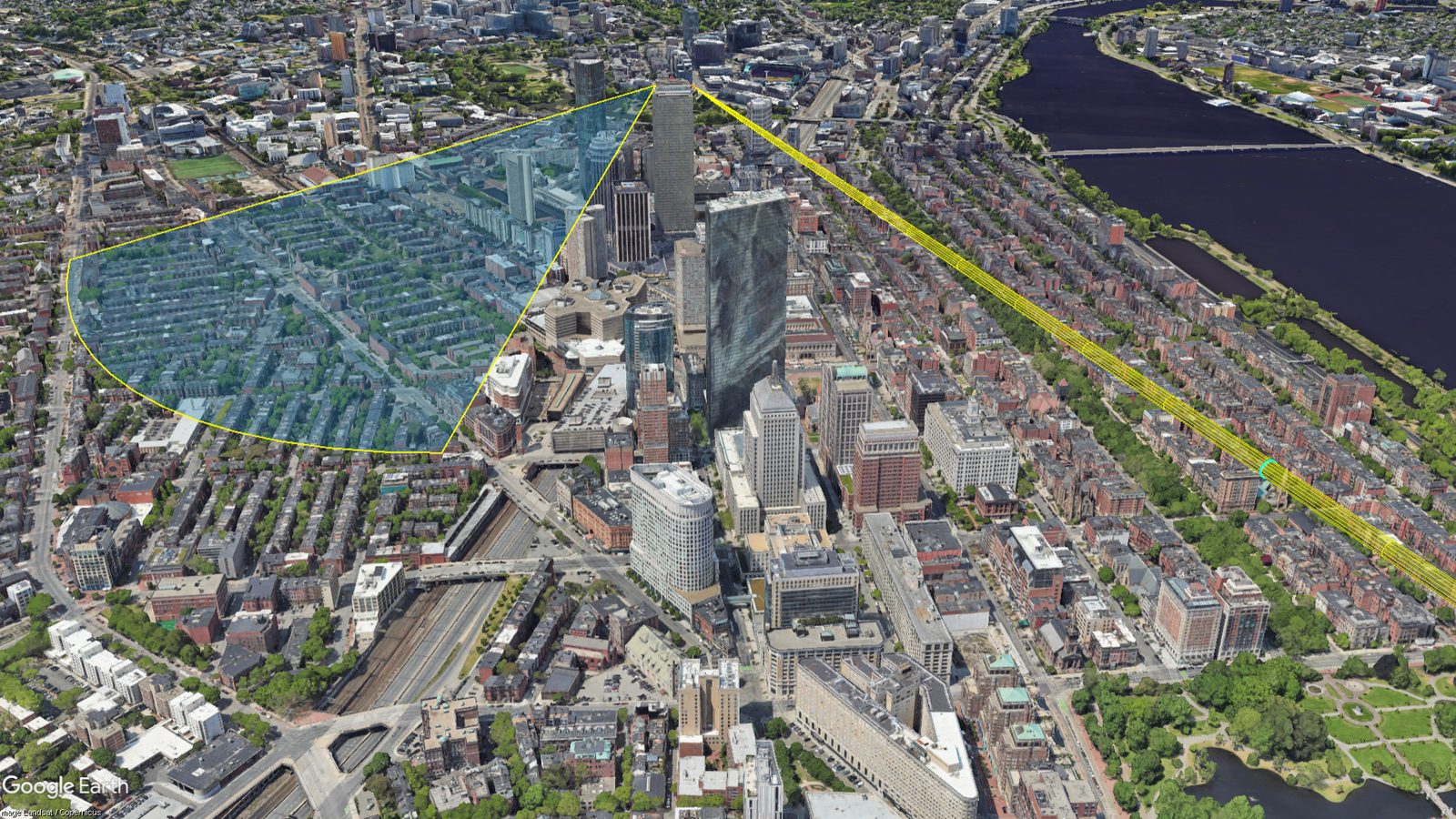
A blue down-tilted antenna sector and a yellow point-to-point Fresnel tube over Boston.
import kmlb

# A 60-degree antenna sector with 15 degrees of down-tilt, on one building corner.
sector = kmlb.shapes.wedge([-71.082195, 42.347025, 228], azimuth=120, width=60,
                           radius=800, tilt=-15, name="Sector")

# A 5.8 GHz point-to-point link from another corner of the same building.
link = kmlb.shapes.fresnel_zone([-71.082399, 42.347435, 228],
                                [-71.058514, 42.358468, 182],
                                freq_mhz=5800, name="ptp-link")

kmlb.kml("RF Scene", [sector, link], path="rf_scene.kml")